Dread maps Interview with Sonia E Barrett
by Phil Cohen
Looking back to your earliest years what would you say were the key moments in your formation as a visual artist?
Both my parents were artists, but they were never able to pursue that. A lot of their work was in the attic, it was never shown. I remember discovering it as child and feeling sad. Another moment was when my step-grandfather took me to Barrett House in Jamaica. He was trying to teach me a lesson about where I came from. Barrett House, and the Barrett plantation has links to the Barretts of Wimpole Street and Elisabeth Barrett Browning, so there was a name link there. Everyone who worked on the plantation took the same name, Barrett, that name branded you as the property of the slave owner. ‘Brownling’ is also what you are called if you are mixed race in Jamaica. When I visited there, I just happened to be wearing a crimson dress which was the same colour as the slave women wore. It was quite an experience. Ever since I have been looking at great houses, here in the UK and in America.
How did you come to get interested in cartography?
My early work dealt with amalgams of objectified people, trees, animals and ores as singular black and brown bodies that reference many unknowable and unknown bodies. I was especially thinking about how they were moved across physical geography, whether across water or land. But the opportunity to work directly with maps came when I was asked to create a work with the Royal Geographical Society, and I was given access to their archive collection of maps on the invitation of CARICUK. But I think I had been working with the idea of the map, of the underlying foundations of European cartography for a long time.
One of the things that interested me about your Dread Maps project was how you went about de-constructing the colonial map, not just in terms of its discursive effect, but in and through a material practice
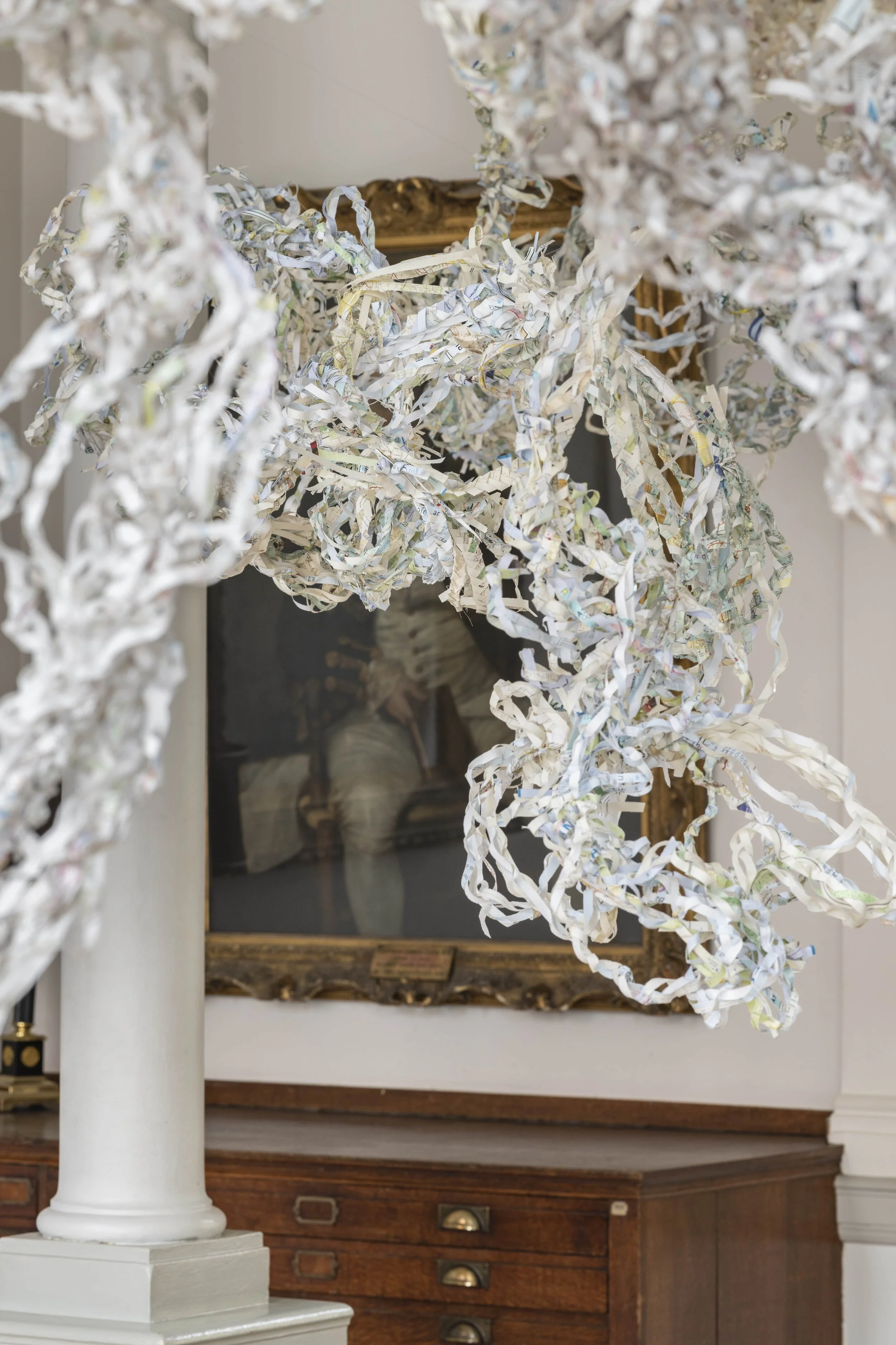
The map is certainly a kind of text, but it has a very material form and effect. Most people don’t question the form. One thing that art can do is to take that form and re-work it. The physical practice of shredding is already a European way of dealing with documents that compromise your identity. Shredding those maps as part of the act to deconstructing the maps that all had the stamp of the British Colonial Office on them seemed an important act, both physical and symbolic. Often when I am working, I try to find a point of contact between Eurocentric ways of thinking and doing and ways that people in the Caribbean or the African continent think and do. The shredder is a ubiquitous office tool, used by governments and businesses, often to erase the traces of their own transactions. On one of the shredders I used for this project there was a label which read ‘use to prevent interference with the identity of your business’. So that seemed a perfect comment on the role of colonial maps, which have had so much to do with interfering with the identities and lives of colonial subjects. Dreading or (dread)locking or braiding is an African Caribbean practice of care. To dread(lock) and plait the shredded map is a reconstructive act of care. So, with the title of the project, Dread can refer to the fear that is aroused by certain kinds of map making which serve as tools of expropriation and set in motion a chain of events which bring people grief. Then there is the other sense of dread, in Jamaican and especially Rastafarian cultures, associated with dreading, to lock the hair in a certain way as a positive self-constructed material sign of identity.

Could you say something about the archive you were working with?
The maps in the Royal Geographical Society archive were from all across the African continent. I brought contemporary maps from The Caribbean and the Southern States of American states, and also old maps from Britain. The maps were from all different eras. Time already constantly undermines the map so I thought it was interesting to combine maps from different times. African and Caribbean geographies are often somehow in Europe never understood as “contemporary” and seen as kind of timeless spaces. I thought it was valuable to use mix up the times the maps were produced.
The notion of shredding also does resonate with one of latent functions of the archive, especially the colonial archive, which is not so much to conserve governmental documents, but to organise it in such a way that the evidence of mis governance is concealed or rendered inaccessible. So the archive becomes a place in which the past is buried rather than remembered. In this context do you think that your work is creating a kind of counter-archive, a kind of ‘anarchive’?
Yes I agree the archive is almost always a place where things are put away to be kept and somehow also forgotten in remembrance. Most archives are accessible to a very few, largely privileged people. Archive is not a word that is used much outside of certain circles. My work is a kind of re-mapping, it is proposing a new kind of map and in that sense is part of a wider project to open up and decolonise the archive. Dread Maps is not just de-construction, it involves a reconstruction, with mapmaking as a collective participatory practice and the mapworks themselves occupying a publicly accessible space. These maps/sculptures create civic space and community.
Could you say a bit more about the platting and braiding element in these mapworks?
It is a way of bringing together all these maps, from different times and places either by platting or locking them, showing their mutual implication. Maps are often distancing devices. We are here in Square One A, and They are over There in Square Three C. With climate change and the pandemic, we need a new kind of cartography, one that explores the inter-connectedness of places foregrounding that rather than the separation of space. By platting and braiding these places together, we are dissolving that kind of cartographic grid. That point was really brought home to me when I came away from that Southern plantation in the USA and came back to London. I initially felt relieved to leave the physical plantation behind but then I gave it a bit more thought and realised that was a crazy relief because I was travelling to London which was the epicentre of the colonial project, and that if you know where and how to look, you could find evidence of that fact.
So there is a kind of space time compression going on here through people’s own cultural practices which may be happening quite independently of globalised visual technologies.
I think there are different levels and forms of compression. There is the forced or involuntary compression of time and place via slavery in the Black Atlantic. Then there is the compression that occurs in diasporic communities, one that can be chosen as a framework for making certain connections between past, present and future. And then compression of digital messaging, they can cut across one another. Place names can actually become de-compressed through cartographic mash-ups. For example, this B in a map fragment could be Birmingham Alabama or Birmingham in the English midlands, or Birmingham in the Caribbean. Platting reconfigures places, un-names or renames them.
That reminds me of a trope in a poem about the Thames by Fred D’Aguiar, in which this once upon a time conduit of Imperial trade is reconfigured by the Black experience as its waves morph into Bob Marley’s Rastaman locks. Turning now to your working methods for this project could you say something about its context and also how the Map-lective group was formed around it?
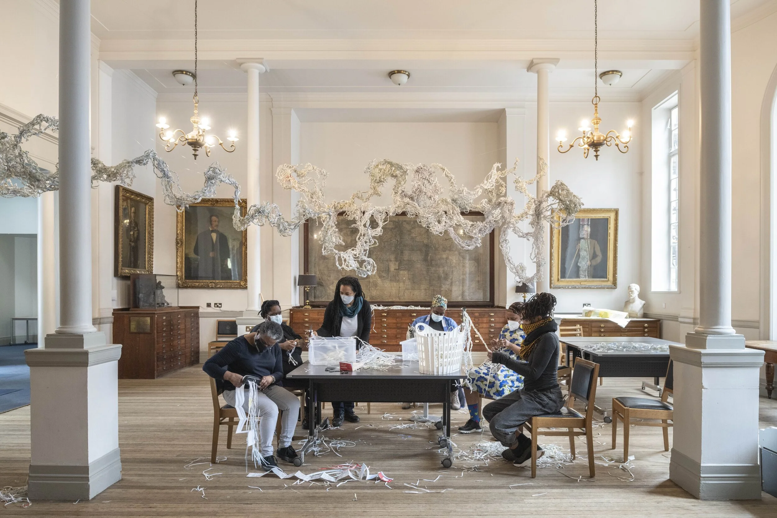
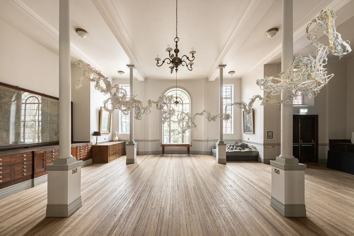
The immediate context for this work was the map room of the Royal geographical Society. Around the wall there are very many portraits of ‘master’ map makers of British history. When I came to research some of these men, I discovered that some of them were delirious with fever as they were conducting their map making and they relied on being carried around by people who lived locally in hammocks. So map making was always a collective multicultural enterprise even though it is often represented as being a singular European endeavour. Then there was the fact that this exercise in geographical reason was carried out by people who were in states of delirium. I felt that if I was to answer back to these individual portraits of white men in the room, it must take the form of some kind of collective undertaking. So we pulled together a group of black and brown women. We platted together for three days, and produced this mapwork which was installed in the room. So we effectively re-framed this site of colonial cartography, because the only way to see the portraits on the walls was to look through our mapwork.
And because the project was funded we were able to invite people to put aside their other work and come in to work on this project. We had quite a diverse group, a geographer, a dancer, a doctor, a chef, a body worker, a linguist, an events organiser, a really broad range. The idea is for the Map-lective to be a flexible form that can respond to different opportunities and environments. So we started with this core and claimed the space for our work. This is a work which creates its own community of practice in order to make the art.
In what ways do you think your approach differs aesthetically or conceptually from mainstream cartography in formal terms?
The work challenges the dominant “common-sense" idea of the map as a flat two-dimensional surface on which everything fixed. Our map in contrast is a three-dimensional flow of swirling elements, of air, light, space, where the paper itself becomes part of that flow. Conventional maps are static and focused on everything that is fixed. However so many of the critical things that are most important are in flow: air as it travels over the land, water as it rises from the soil and return to the soil, nutrients as they travel and are transported though the soil. It is no accident that these very elements that the map renders invisible are also not recognised by capitalism. If we are going to use cartography to address issue of climate change, and racial and social injustice we have to develop a new methodology which can represent these more fluid configurations. Instead, maps continue to be about drawing lines between people here and people there, this is my property, that is yours, claiming territory, creating borders.
This reminds me of an old adage about the colonial project: In the beginning, we had the territory and you had the maps. Now you have our territory and we have your maps. In the decolonisation process, the relation between map and territory is transformed. The map is no longer a purely active, inscriptive process which expropriates or transforms the territory, the territory strikes back and deconstructs the map and its Empire of signs.
Exactly. The map is never neutral. The landscape is always active, it is being rendered passive by the map. The work releases the map and the idea of territory.
This seems to be one of the key things we have to learn from indigenous cartographies, and how they work to transcribe that environmental dynamic, whether through social ritual or by graphic means. And also that their notion of territory is very different from the European one based on fixed boundaries.
It’s not enough to refute the official map. One of the things I notice in African colonial maps is that they often had blank spaces marked ‘Nature Reserve’ which turn out to actually be tribal lands, which were treated by the Colonial authorities as ‘people reserves’. But then many of the people geo-located in these so called reservations moved around a lot, with their animals, and according to the season, so their territory actually consisted of trajectories of movement which cross the boundaries and borders being imposed on them. They needed to be able to be in constant dynamic chorus with the lands and every presence around them. To try and defend their land rights you have to adopt their methods of mapping, their ways of navigating and making sense of the environment. Otherwise you have already lost the battle.
Yes of course, lines can be used to circumscribe and confine and exclude, but they can also be taken for a walk, as Paul Klee insisted is his pedagogic discourse on the art of drawing. They can be genuinely exploratory and open up new possibilities. How we drawn the line is as important as where we draw it. They can be way of marking and holding to a stance of opposition or resistance to the powers that be.
Each individual line in ‘Dread map’ is an entanglement, a point of intersection with many other lines. Any time you try to follow a line you find yourself caught up in a whole non-linear ungrid of spatial representation. So it’s not really about making a device that is tracing and disentangling the knots of Colonial power, but about becoming part of a counter-movement which unravels the whole Eurocentric mode of spatiality upon which colonial power, and environmental destruction rests.
Perhaps there is some relation here to what urban planners call ’lines of desire’, unofficial paths which are made across an area by people’s footfall, often walking off the beaten track, or taking short cuts, following their own whims or interests, releasing themselves from the straightjacket of the rational urban grid, of having to go from A to B, home to work, in a straight line. How to introduce that alternative mode of navigation into the map making process itself, or to make the kinds of maps which encourage it, is one of the key challenges facing counter mappers.
I think what I am about in the way I work, is to unfix the map and generate alternative mappings which emerge out of a collective process, in the flow of ideas, which is analogous to that kind of everyday navigational process.
For more about Sonia’s work, please visit: https://www.sebarrett.com
Follow on Instagram @soniaelizabethbarrett
Photo Credit: Damian Griffiths
For more about the Map-lective project, please visit: https://www.map-lective.com
Information about CARICUK https://caricuk.co.uk/provocations/dreading-the-map/